digital. stories. by Patrick Brown
  • Home
  • About
    • About Me
    • About digital. stories.
    • My Books
  • Blog
    • Adventure
    • Aerial Photography
    • Antarctica 2012
    • Grand Canyon 2014
    • Kayaking
    • New Years
    • Road Trip 2013
    • Technology
  • Photos
  • Videos
  • Maps and GPS
  • Projects
    • Van
      • Van For Sale
    • House
    • Technology
    • LASP
Search the site...
  • Home
  • Posts tagged "mapping"

Posts tagged "mapping"

BVCB Bike Tour

September 7, 2012 / Pat Brown / Adventure, Stories

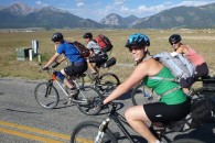
Although the 2012 drought has been less than ideal for kayaking, the upshot has been that I’ve been able to get out on my mountain bike more this year than in the past several years combined. So when my good friend, Scott, suggested a Labor Day weekend bike trip from Buena Vista to Crested Butte, […]

Read More

digital, gps, mapping, photos, stories

Tour d’Ark Follow Along

June 30, 2010 / Pat Brown / Adventure, Kayaking

This Thursday morning, I will begin 5 days of whitewater kayaking with several friends down the Arkansas River in Colorado starting on the Granite section and ending in Canon City almost 100 miles later. The trip was dreamt up by Scott Winkleman as a perfect way to see all of the whitewater sections of the […]

Read More

mapping, outdoors, SPOT

Gates of Lodore Follow Along

June 17, 2010 / Pat Brown / Adventure, Kayaking

On Saturday, June 19, I will embark with my friends on a 4 day whitewater trip down the Green River through the Gates of Lodore in Dinosaur National Monument! This is a wonderful trip through desert country in northwest Colorado that is sure to be a good time! As I’ve done in the past, I […]

Read More

mapping, outdoors, SPOT

Pole Pedal Paddle

April 19, 2010 / Pat Brown / Adventure, Kayaking, Stories

What do you get when you strap a camera to a ski pole, then to mountain bike handle bars, and then kayak one handed so you can film the river? You get my decidedly “recreational” entry in the 2010 Salida Pole Pedal Paddle race and you get a fun, first person view of the race […]

Read More

mapping, outdoors, stories, video

A Historic High Altitude Balloon

April 16, 2010 / Pat Brown / Aerial Photography, LASP, Stories, Technology

This morning will mark the third flight of the camera/SPOT balloon package to the edge of space in 2010. The flight is another education and public outreach (EPO) opportunity that is taking place in conjunction with the Boulder History Museum. They are working with a local middle school to film and produce a short documentary […]

Read More

balloon, mapping, SPOT, stories

Lucky Balloon!

March 25, 2010 / Pat Brown / Aerial Photography, LASP, Stories, Technology

If you read the pre-flight article, you’d remember that I ended by saying, “Let’s hope for the Luck o’ the Irish for the ole’ balloon!” As it turned out, this balloon flight definitely needed the luck of the Irish. After a perfect launch into a blue-bird Colorado sky, we casually began to follow the SPOT […]

Read More

balloon, digital, gps, mapping, photos, SPOT, stories

Google Earth Network Links

January 23, 2010 / Pat Brown / GPS, Technology

Download my Google Earth network link, open it in Google Earth, and then save it to My Places in G.E. The next time you open Google Earth, my network links will automatically appear in the left pane under places and will have all the latest KMZ files that I have added!

Read More

digital, mapping, web

Edge of Space Follow-Up

January 7, 2010 / Pat Brown / Aerial Photography, Stories, Technology

The expanded analysis of the January 5 balloon flight to the edge of space is finally available! If you aren’t a geek, you will be probably be satisfied with the YouTube documentary and photo albums that are presented below. But if you have been asking questions like, “How high did it go?”, or “How come […]

Read More

digital, gps, mapping, SPOT, stories, video

Mission Accomplished!

January 6, 2010 / Pat Brown / Aerial Photography, Stories, Technology

The balloon launched successfully at 9:36am and was recovered in perfect condition 154 miles southeast of the launch site at 1:55pm! The camera was still taking photos at one minute intervals over 4 hours after the intervelometer was started, and it grabbed this great photo of all of us checking out our baby! I haven’t […]

Read More

digital, gps, mapping, stories

Gunny Gorge

September 9, 2009 / Pat Brown / Adventure, Kayaking, Stories

Labor Day weekend in Gunny Gorge. What could be better? I’ll tell you what, not a whole lot. I have to thank Scott for conceiving of and organizing this really cool self-support, overnight kayak trip through Gunny Gorge. In addition to those responsibilities, he also carried all of the group gear and food in his […]

Read More

kayak, mapping, outdoors, stories
123
Copyright 2013 Patrick Brown